Digital land sprint notes
This was a busy sprint for the whole team. Amongst other things, we made some great progress working with Buckinghamshire Council to publish a page per development plan document on our site. We also did further work with our policy colleagues on our roadmap to prioritise our work and make sure we can help successfully deliver the digital aspects of the Planning Reforms.
Development Plan Documents
Building on what we did in the last sprint we now have all the development plan documents for Buckinghamshire Council in full detail.
For each development policy you can now see:
- A map of the area it covers
- A record of the organisation that wrote the policy (in the case of Buckinghamshire Council this has been complex as it was previously made up of a number of different councils)
- A link back to the organisation
- A link to the specific geographical area
- A url link to take you to the original published Development Plan Document
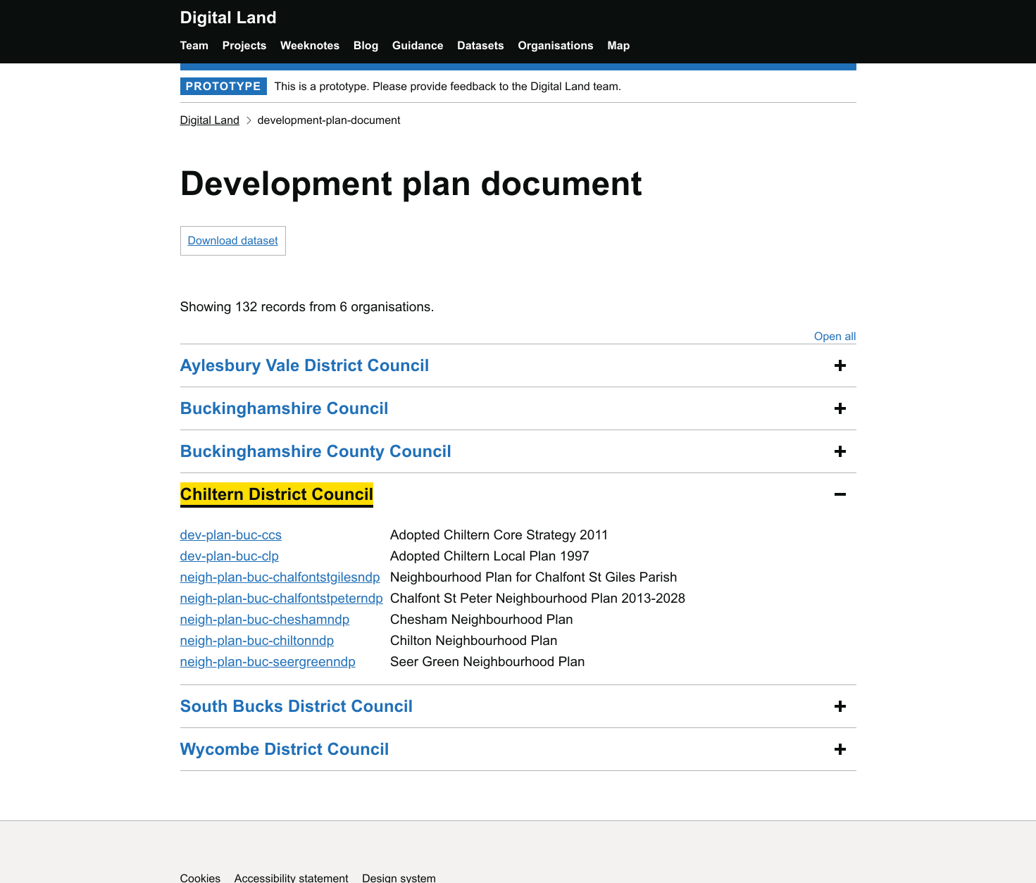
We have also worked with our other pilot Local Authorities; Lambeth and Southwark to collect their development plan data. Having demonstrated getting the data from Buckinghamshire onto the site we can now easily do the same for Lambeth and Southwark.
In a future sprint we will explore collecting copies of the documents. We know that PDF documents are updated and are sometimes moved. Having copies of the documents means users of the data will always have access to the referenced documents.
What we have learnt here will help inform the future pilots on local plans which will be part of the wider planning reforms.
Feedback Loops
For a little while now we have been thinking about what our ‘feedback loop’ feature should be i.e. how do we make actors of our service aware of various events? We want to make sure that when we publish data it’s accurate and anyone who uses it can tell us easily if they spot a problem so we can either sort it out or pass on the feedback to whoever is the custodian of the data. We also want to make sure we have an easy way for our users to be able to communicate with us more generally.
Loïc, Matt and Colm worked together to map out the different scenarios where a feedback loop might be needed, and to understand the current user journeys involved in those.
This is a work in progress and you can see a version of that map here:
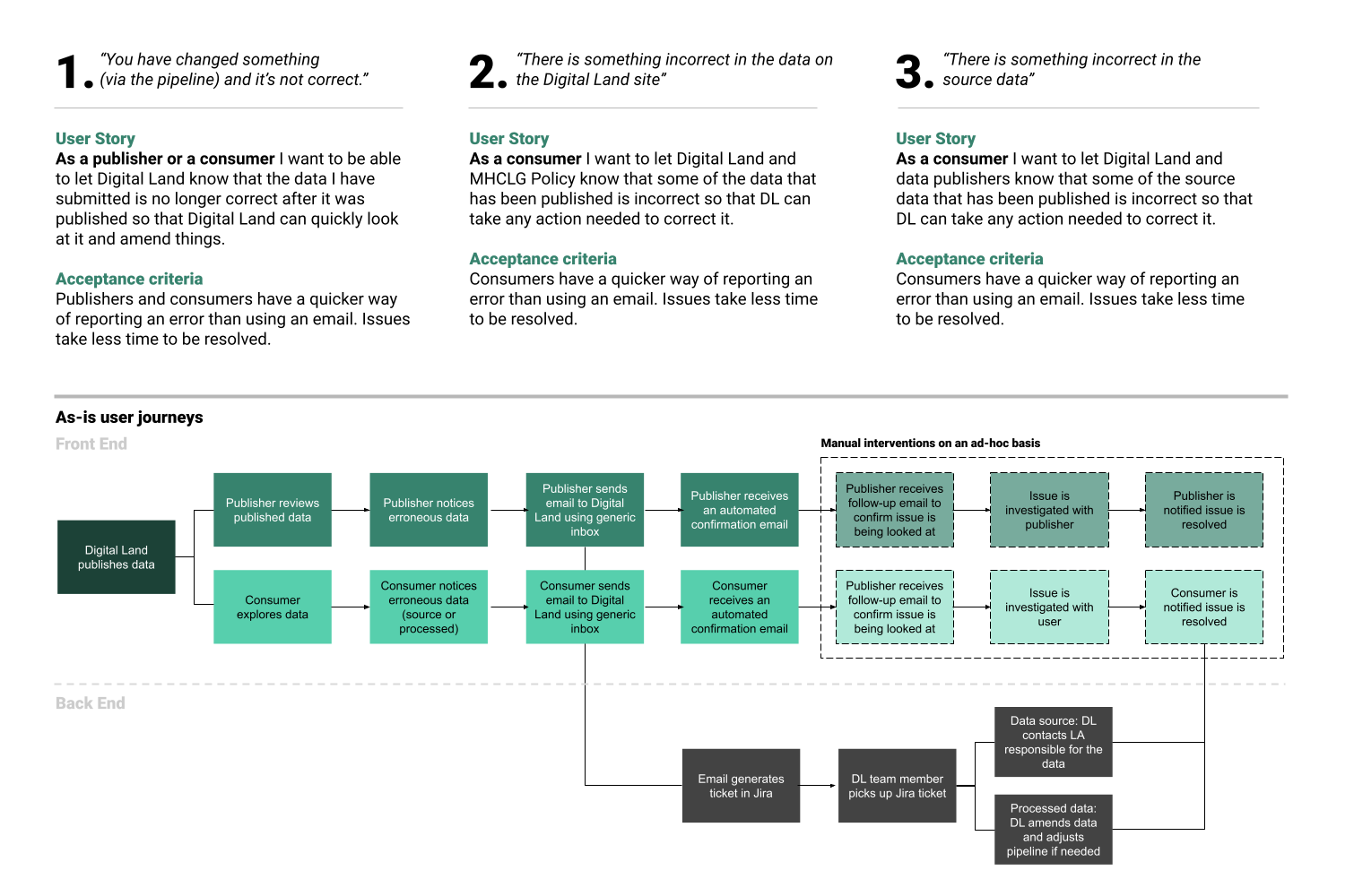
In our upcoming sprint Loïc will be designing the feature for reporting issues in the data.
PropTech
Jess was happy to be part of the first PropTech Innovation Network event organised by DIN, speaking about our PropTech work with 70 attendees across the social housing sector. It was great to hear questions from a variety of Housing Associations and listen to the experience of people working to drive digital transformation internally.
We also attended a couple of key discussions around digital citizen engagement, one organised by CitizenLab on 20 January and another by Commonplace where they launched their new Engaging for the Future eBook.
More widely this sprint we've been engaged with colleagues in home ownership, social housing, and housing delivery and are supporting Innovate UK on a new digital planning pilot.
Making sure we can reuse as much as possible
We have a “design system” which is essentially a technical catalogue for common features which we use again. Having this design system will make it easier to reuse things and share our learning on what has worked well - ultimately making it easier and faster to get things done in the future. In this sprint Colm used experience from our prototypes to improve how we create maps and make sure this can be used by Jon, Kishan and others on the team in the future.
Permitted Development Rights and Article 4 Directions
In this sprint we also focused on getting together a list of permitted development rights from the General Permitted Development Order - which on the whole is not easy to search through - into a machine readable format. This list has all the permitted development rights set out in one place, which means in the future all Article 4 directions can link directly to this and can be easily found.
We will continue to work on this, and so it can be accessed on our platform, and also so other projects such as Reducing Invalid Planning Applications (RIPA) can access the data it needs.
Conservation Areas
We have continued to gather conservation area data published by Local Planning Authorities, so that, similar to Article 4 Directions, RIPA can help users identify where planning permission may be required.
After many improvements to the processing rules, we now have over 4,500 conversation areas listed on our site (previously only ~1800 were successfully processed by us), which can be seen on our conservation area pages.
We still have some work to do on this to continue to gather all the known conservation areas and publish them as data. One of the challenges is that we have found a different number of conservation areas from different sources. Historic England estimates that there are approximately 10,000 across England, which gives us a sense of the numbers we are looking at.